Flood mitigation in Darwin region
Issues with flooding in the Darwin region are largely dependent on locality.
A number of areas have historically experienced flooding associated with unmitigated stormwater flows.
Darwin flood mitigation report
The Darwin Regional Flood Mitigation Advisory Committee released a report that provides specific recommendations and measures for managing and reducing the flood risk in the Darwin region.
Read the final Darwin flood mitigation report 2015 PDF (2.2 MB).
Projects
The department is leading the implementation of the recommended measures as per the committee's report for the following key areas:
Rapid Creek
Flooding can occur in the Rapid Creek catchment when heavy rain combines with high tides to cause flood water to back up into the creek and flood low-lying properties.
During Cyclone Carlos in 2011, approximately 67 properties were impacted by inundation of floodwater from Rapid Creek.
The Northern Territory Government (NTG) is working to alleviate the impact of flooding in the Rapid Creek catchment.
Construction of a detention basin, combined with other flood mitigation measures, will reduce the impact of flooding on downstream properties.
Marrara detention basin
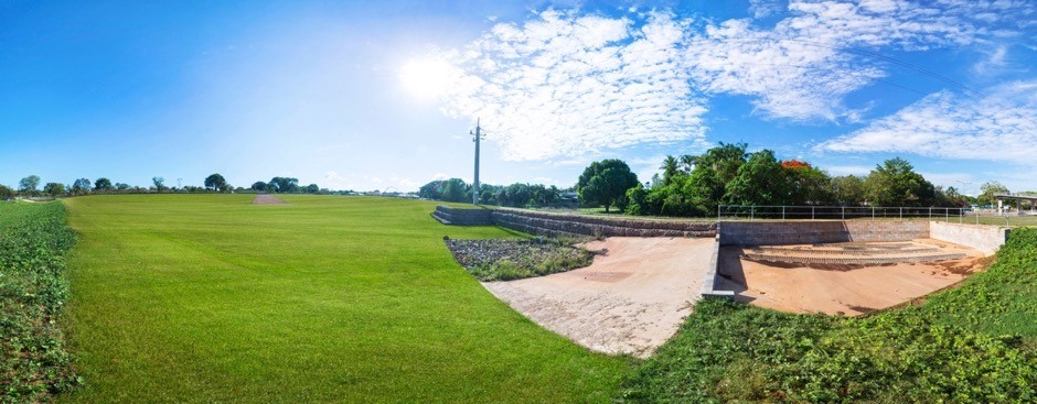
A detention basin has been built on the corner of McMillans Road and Henry Wrigley Drive in Marrara to temporarily hold stormwater flows from Anula, Moil and parts of Marrara, during large rainfall events.
The construction tender was re-released in early 2018 after low levels of Per- and Polyfluoroalkyl Substances (PFAS) were identified within soils at the detention basin site.
The department has undertaken environmental testing in accordance with the National Environment Protection Measure (NEPM) guidelines, which has shown soils within this site to have low levels of Per- and Polyfluoroalkyl Substances (PFAS) present, significantly below the Health Based Guidance Values for PFAS.
Management of excess soils from this project was undertaken in accordance with independent environmental advice and endorsed by NTEPA.
The design of the basin sought to retain as much native vegetation as possible, with land cleared for the perimeter embankment only, while the excavation for the basin floor is in the previously cleared part of the site.
The basin floor and embankment is grassed to stabilise it against erosion and promote infiltration to groundwater, while remaining free draining, detaining water generally no longer than 24 hours after a large rainfall event.

The basin is designed to slowly fill from the inside out (see image above) and to detain water in a large Q100 rainfall event (i.e Cyclone Carlos) with outlets fenced for safety reasons. On completion the primary purpose of the area will remain as open space given it will remain dry when it is not raining.
Construction of the detention basin was completed in 2019.
Early warning system
An early warning system has been put in place to help residents prepare for the risk of potential flooding and enable them to activate their emergency household plan.
NT Emergency Services monitors the conditions of Rapid Creek in the event of heavy rainfall. A warning is triggered in the event that Rapid Creek rises to a level that is considered a flood risk, whereby NT Emergency Services will give warning to impacted residents.
For more information on how to prepare a household emergency plan, go to the SecureNT website.
For river height information for Rapid Creek, go to the Bureau of Meteorology’s website.
Darwin International Airport
NT Airports has committed to undertaking flood mitigation works to manage stormwater runoff from the Darwin International Airport as recognised in their master plan 2017.
Back-flow prevention devices
The department has worked with Power and Water Corporation to install back-flow prevention devices into homes that are at risk of sewerage inundation during heavy rainfall events.
Retaining Rapid Creek in its current state
Rapid Creek is a well-functioning system and will be retained in its current state.
A strategy has been put in place to ensure the infrastructure in the creek, such as culverts and bridges, are maintained and continue to work efficiently.
Rapid Creek flood response overlay
The mid suburbs area plan allows for the provision of a change in zoning for properties that remain impacted by potential flooding in Rapid Creek.
The department has undertaken the necessary flood study within this area to facilitate the introduction of the Rapid Creek flood response overlay into the Planning Scheme, which is to allow impacted properties to redevelop their property so that the minimum floor level is above the flood level.
This can only be done subject to certain planning conditions.
For more information refer to:
- Darwin mid suburbs area plan - part 2, 3.1, concept C PDF (395.8 KB)
- Rapid Creek flood response overlay in part 3 of the NT Planning Scheme - go to the NTG website.
Updated Rapid Creek flood maps
Updated flood mapping for Rapid Creek, which now includes the stormwater detention basin constructed in 2019, has resulted in a reduced impact of flooding on more than 100 downstream properties.
This includes 45 properties that are no longer on the Rapid Creek flood map.
Updated storm surge mapping was also undertaken by the NTG in the Rapid Creek catchment using improved topography and data.
This has resulted in 58 properties that are no longer on the Darwin Storm Surge primary flood extent map.
For an updated Darwin storm surge map, go the Northern Territory Government website.
Ludmilla
The suburb of The Narrows sits within the relatively large but heavily developed Ludmilla Creek catchment and has experienced flooding frequently since 1990.

To minimise the impact of flooding in Ludmilla and the Narrows, DIPL has completed the following flood mitigation measures in partnership with the City of Darwin and Department of Defence:
- construction of earth embankment and upgraded drainage in Dwyer Park to convey stormwater to the Sadgroves Creek catchment and away from Ludmilla Creek
- upgrading trunk drainage along Reichardt and Benison Roads
- installing larger culverts under Tiger Brennan Drive
- building a detention embankment basin, staged detention basin and diversion drain on RAAF Base Darwin
- re-establishment of Ludmilla Creek trunk drain (stage 1) in 2015. Extension to the culverts under Dickward Drive (stage 2) is on hold pending the approved management of excess material containing PFAS.
Yarrawonga
There are significant issues with drainage in the Yarrawonga industrial areas, with flooding occurring in relatively small rainfall events.
The Northern Territory Government is working to alleviate the impact of localised flooding in the Yarrawonga catchment.
The flood mitigation measures include:
- upgrading trunk stormwater drainage on the western side of Yarrawonga;
- Installing new culverts under Wallaby Holtze Road; and
- upgrading stormwater drainage along Tulagi Road.

The City of Palmerston has upgraded Yarrawonga Road and Wallaby Holtze Road including upgraded drainage.
DIPL will upgrade stormwater drainage on Tulagi Road, which is expected to commence in the later half of 2018.
Stormwater drainage is expected to be upgraded in the western area of the industrial estate, near McKenzie Place, by late 2019.
Wadham Lagoon, Howard Springs
Flooding occurs around Wadham Lagoon in Howard Springs with a number of private properties affected during large rainfall events.
The Northern Territory Government is working to alleviate the impact of localised flooding in the Wadham Lagoon catchment in two stages:
- stage one: install new culverts beneath Whitewood Road, completed to be commissioned on completion of stage two
- stage two: upgrading sections of the trunk drain between Whitewood Road and Howard Springs Forestry Reserve outfall and relocate underground Telstra communications and water mains at road crossings along the trunk drain.
The Wadham Lagoon flood mitigation project will increase the capacity of trunk drainage to cater for flood stormwater flows in large rainfall events.
The flood model over this catchment will inform assessment of future developments in the Howard Springs activity centre to manage stormwater to pre-development flows.

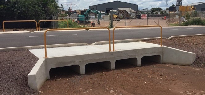
Stage one has been completed with new culverts installed beneath Whitewood Road in mid-2017 (see image above).
Stage two is expected to be completed by the end of 2019.
Rural area
Lorikeet Court, Herbert
During Cyclone Carlos in 2011, significant flooding of properties occurred in Lorikeet Court in Herbert.
Works were completed by mid-2015 comprising drainage upgrades and new culverts to mitigate flooding.
Wells Creek, Virginia
Wells Creek Road is frequently closed during monsoonal rains.
Investigation and analysis of the catchment is currently in process.
Elizabeth River, Noonamah
A number of rural properties are impacted by inundation during monsoonal rain and cyclonic storms on the Elizabeth River.
Investigation and analysis of the catchment is currently in process.
More information
For information on the range of structural and non-structural flood mitigation options, read about flood mitigation measures.
For the latest updates on flood mitigation projects in other regions of the NT, read about flood mitigation.
Give feedback about this page.
Share this page:
URL copied!